NeurIPS 2026

Adapting Actively on the Fly: Relevance-Guided Online Meta-Learning with Latent Concepts for Geospatial Discovery

A relevance-guided framework for sequential geospatial discovery under sparse labels, strict acquisition budgets, and spatial or temporal distribution shift.
Jowaria Khan · Anindya Sarkar · Yevgeniy Vorobeychik · Elizabeth Bondi-Kelly
University of Michigan · Washington University in St. Louis
PaperarXivCode · coming soonResults
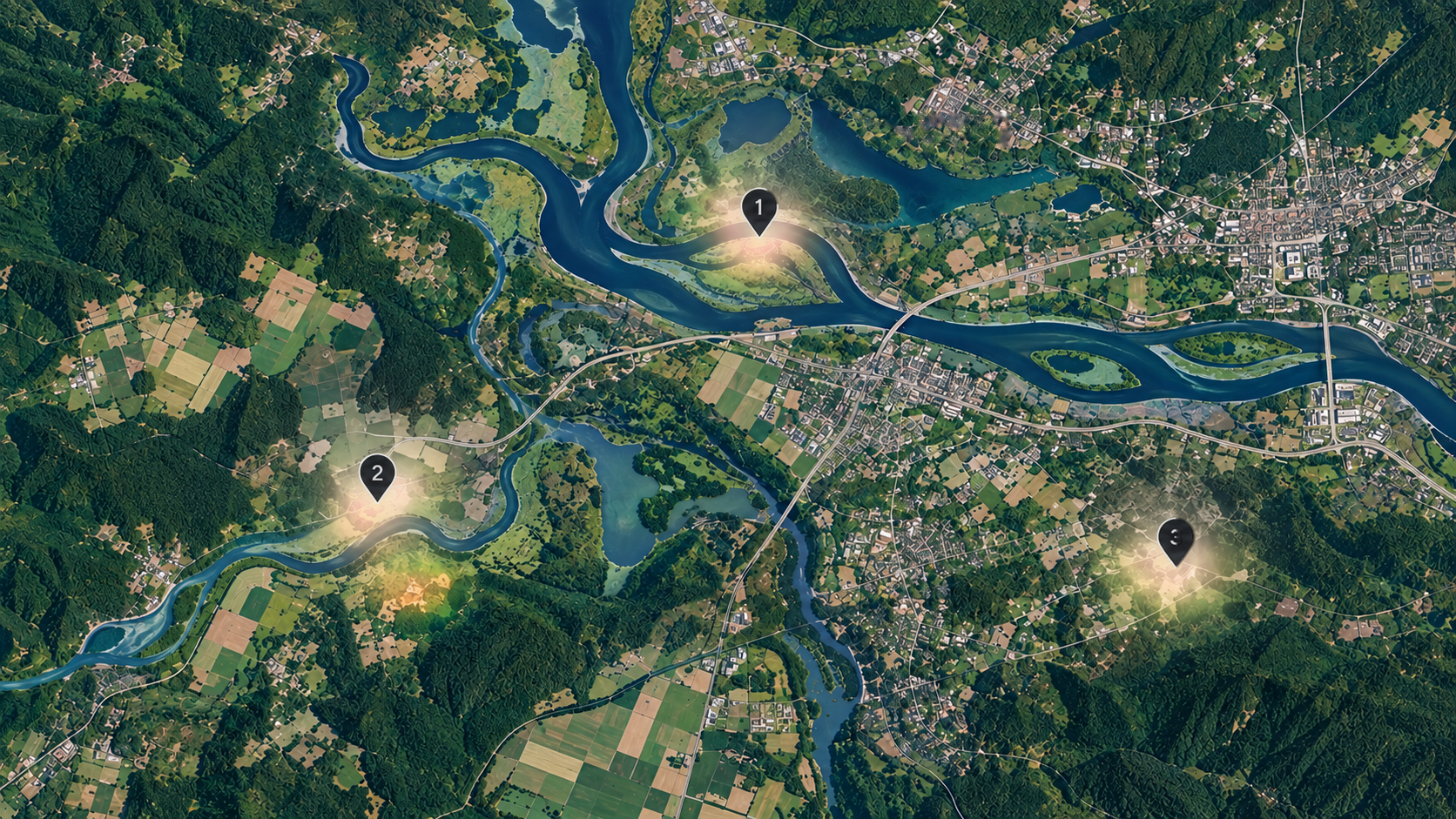
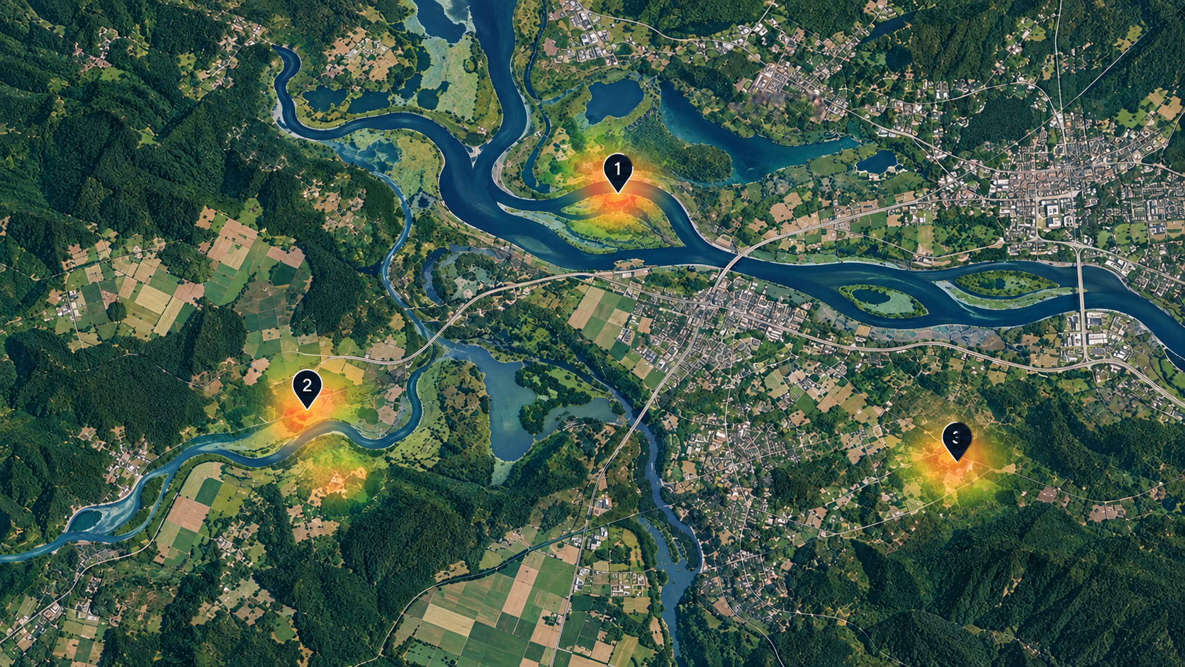
Real remote-sensing landscape used to illustrate sequential environmental discovery. Environmental landscape with a learned relevance field over candidate regions.
learned relevance current query
1
2
3
OWL-GPS LOOP

Represent environmental context for each region.

Domain-informed concepts summarize the environmental context associated with each candidate region.

Estimate region-specific relevance.

The learned relevance representation assigns different importance to different regions under the current model.

Select a high-value region under budget.

The acquisition rule uses the current predictions and relevance representation to choose which region to label next.

Update online and recompute relevance.

The newly acquired label updates the predictor, after which relevance is recomputed for the remaining candidate regions.

Acquire again from the updated model.

The next acquisition reflects the model state after incorporating the latest supervision rather than a fixed ranking made at the start.

Repeat the adaptation step.

Each new observation can change both the predictor and which concepts are most relevant for subsequent acquisition decisions.

Continue sequential acquisition.

The process continues under the remaining query budget: acquire, update online, recompute relevance, and choose again.
Context
Relevance
Query 1
Adapt + recompute
Query 2
Adapt + recompute
Query 3
01ContextEnvironmental and spatial context describe each candidate region.
02RelevanceA learned field highlights where the model should focus next.
03AcquireThe current best region is queried under a limited budget.
04AdaptNew supervision updates the model and shifts the field.

Sequential acquisition

The learner decides which region to label next under a strict query budget.

Online adaptation

Newly acquired observations update the model and change later acquisition decisions.

Shared relevance geometry

The same learned concept-relevance space guides both sampling and meta-batch construction.

01 / problem
From environmental prediction to budgeted discovery.
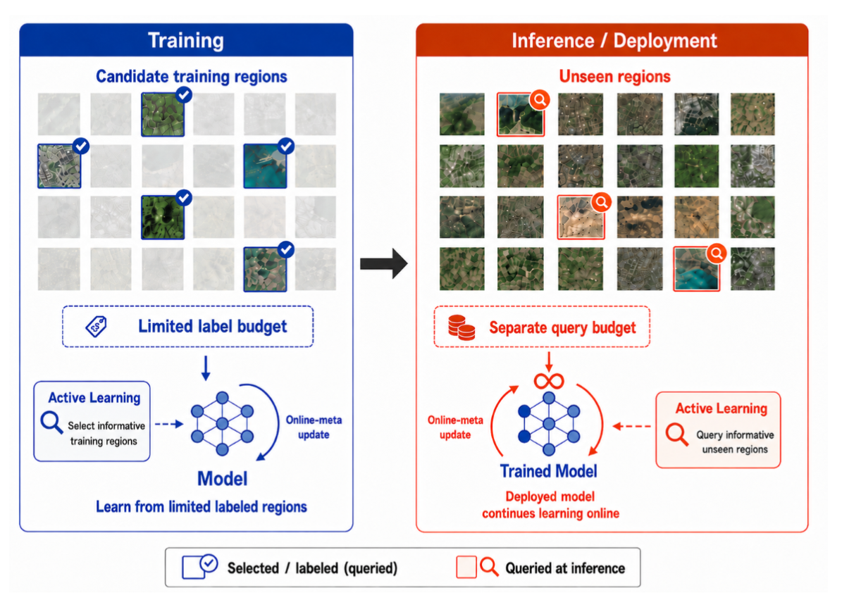
OWL-GPS treats environmental deployment as an evolving decision process: candidate regions can be scored, but labels are acquired sequentially and the model keeps adapting as new measurements arrive.
OWL-GPS problem formulation from the paper
Problem formulation from the paper: sequential geospatial acquisition with limited supervision and a deployment-time discovery budget.

Costly supervision

Many environmental targets require field sampling, laboratory analysis, or other costly measurements, making supervision sparse and expensive.

Spatial and temporal shift

The model may encounter new regions or later years whose environmental conditions differ from the data used to initialize the predictor.

Acquisition changes adaptation

Every query determines which supervision becomes available next; every update changes which region looks most valuable to query afterward.

02 / method
A shared relevance representation.
The method learns region-specific concept relevance and reuses it across prediction, acquisition, and online adaptation.
OWL-GPS framework diagram from the paper
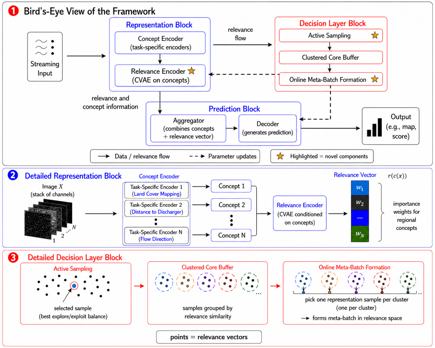
The paper’s framework diagram: concept encoding, relevance estimation, active sampling, bounded memory, and online meta-batch formation.

Concept encoder

Domain-informed environmental channels are embedded into structured latent concepts.

Relevance encoder

A conditional latent variable represents which concepts matter most for a particular region.

Two downstream uses

Relevance-space structure helps select new regions and also selects diverse observations for subsequent meta-updates.

03 / results
Evaluation across environmental discovery settings.
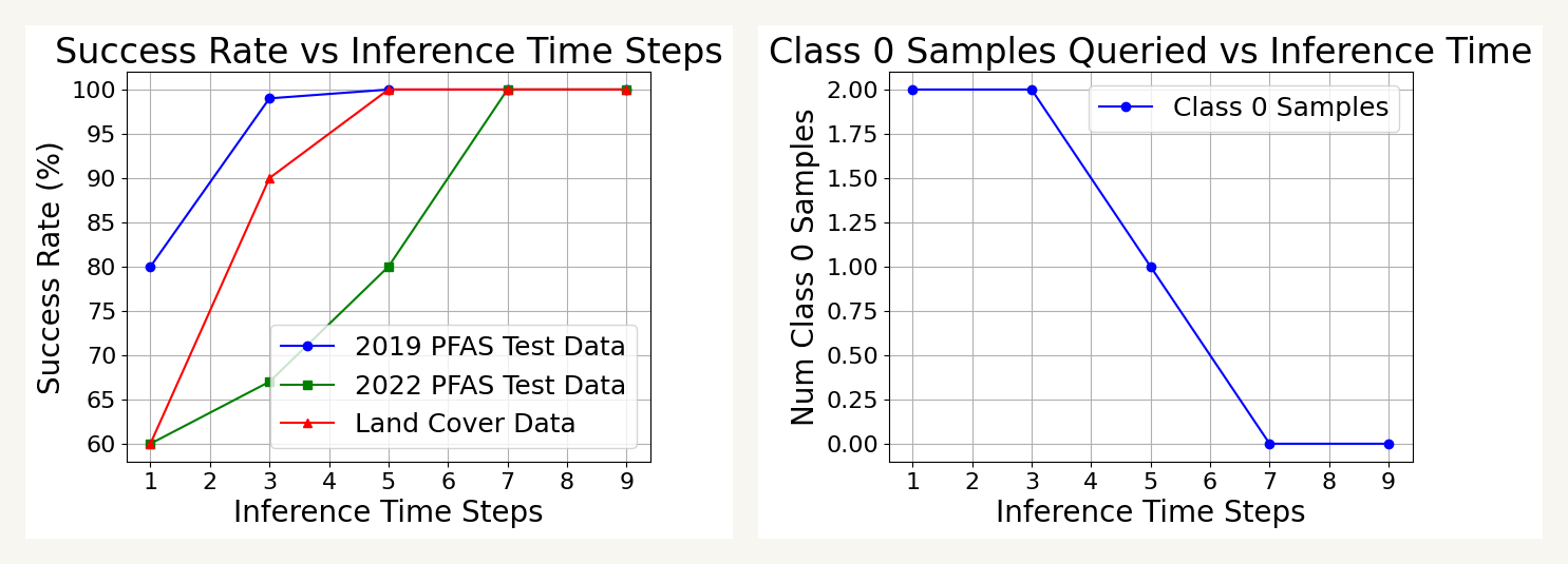
We evaluate OWL-GPS primarily on real-world PFAS contamination discovery, then test temporal transfer and a separate land-cover task to examine portability beyond the primary application.
metric / setting
ours
best baseline
2019 PFAS · Success Rate
98
95
2019 PFAS · F-score
65
61
2019 → 2022 · Success Rate
86
81
Land cover · F-score
71
48
Search performance and exploration behavior figure from the paper
Search behavior from the paper across the primary environmental case study and transfer settings.
04 / interpretability
Relevance is local to the region.
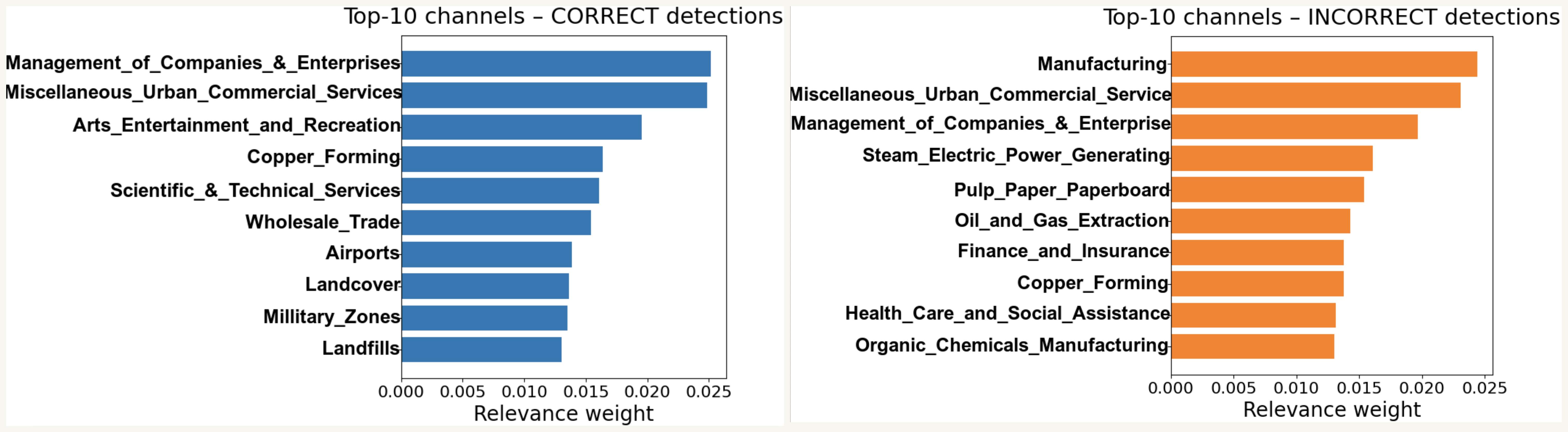
Different geospatial regions can emphasize different concepts, rather than following one fixed global feature ordering.
Concept relevance visualization from the paper
Paper visualization of the top concept-relevance channels for correct and incorrect predictions.
The same relevance representation supports prediction, acquisition, and online adaptation.
NeurIPS 2026

Adapting Actively on the Fly

Code and reproducibility materials will be released soon.

Open PDFarXivCode · coming soonBack to top